
Sipi Falls, Kapchorwa | Uganda
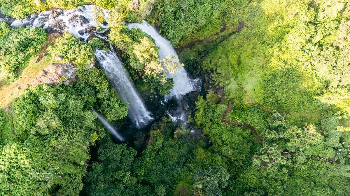
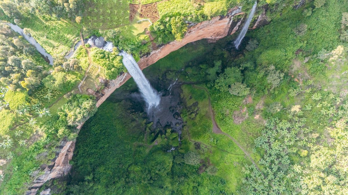
Sipi Falls, located in eastern Uganda near the town of Kapchorwa, is a breathtaking series of three cascading waterfalls (Sipi, Ngasire and Simba Falls) set against the rugged slopes of Mount Elgon.
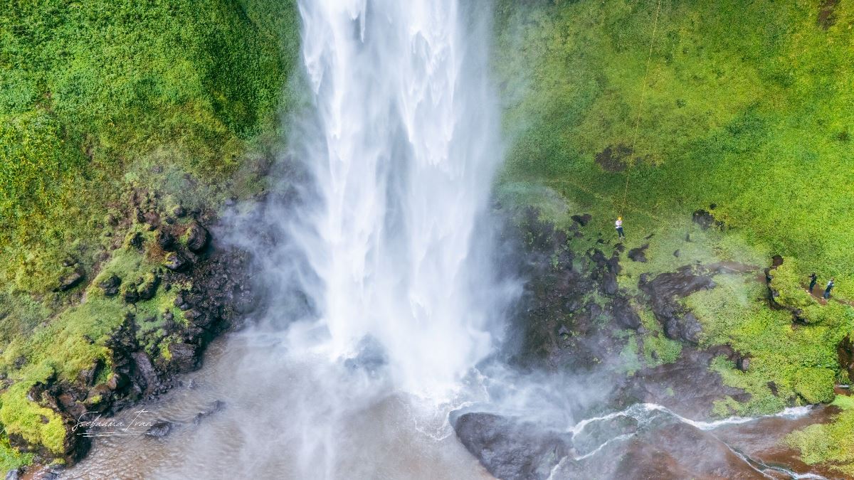
Renowned for its stunning natural beauty, the falls are formed by the Sipi River, which tumbles down dramatic cliffs, with the main cascade plunging over 100 meters.
Surrounded by lush greenery, coffee plantations, and panoramic views of the rolling plains below, Sipi Falls is a haven for nature lovers, hikers, and adventure seekers.
The area offers not only mesmerizing scenery but also cultural experiences with the local Sabiny and Bagisu communities, making it a must-visit destination for those exploring Uganda’s diverse landscapes.
Sipi Falls Location, Uganda
Sipi Falls, one of Uganda’s most iconic natural attractions, is renowned for its stunning trio of waterfalls and its picturesque setting on the western slopes of Mount Elgon.
Located in eastern Uganda, near the border with Kenya, the falls are a highlight of Kapchorwa District and serve as a gateway to the broader Mount Elgon region.
The area’s highland geography, lush vegetation, and proximity to Sipi Town make it a focal point for tourism, offering a blend of natural beauty, adventure, and cultural experiences.
Geographical Coordinates and Setting of Sipi Falls, Uganda
Coordinates: Sipi Falls is situated at approximately 1.33°N latitude and 34.38°E longitude, placing it in the highlands of eastern Uganda.
Elevation: The falls lie at an altitude of about 1,800 to 2,000 meters (5,900 to 6,560 feet) above sea level, contributing to its cool climate and scenic vistas.
Geographical Features: The falls are formed by the Sipi River, which originates on Mount Elgon and cascades down steep volcanic cliffs. The three waterfalls are set within a rugged landscape of montane forests, coffee plantations, and rocky gorges.
Proximity to Mount Elgon: Sipi Falls is located on the lower western slopes of Mount Elgon, an extinct volcanic mountain straddling the Uganda-Kenya border. The falls are part of the broader Mount Elgon ecosystem, which includes Mount Elgon National Park, known for its diverse flora, fauna, and volcanic features like calderas and hot springs.
Regional Context
- District and Town: Sipi Falls is in Kapchorwa District, with Sipi Town serving as the nearest settlement and primary base for visitors. Sipi Town, a small rural hub, is approximately 5-15 minutes by road or foot from the falls, depending on the specific waterfall.
Sipi Falls Distance from Major Cities:
Mbale: The nearest major city, about 45 km southwest of Sipi Falls (1-hour drive via the Mbale-Kapchorwa Road).
Kampala: Uganda’s capital, approximately 275 km west (5-6 hours by road, depending on traffic and road conditions).
Jinja: A popular tourist hub near Lake Victoria, about 180 km southwest (3-4 hours by road).
Proximity to Kenya: The falls are close to the Uganda-Kenya border, with the Kenyan town of Kitale approximately 70 km away, making Sipi Falls accessible for cross-border travelers exploring the Mount Elgon region.
Surrounding Areas: The falls are near other notable sites, including Mount Elgon National Park (20-30 km to park entrances), the Bulambuli Hot Springs (30-45 minutes’ drive), and local Sabiny and Bagisu villages within 5-10 km of Sipi Town.
Sipi Falls Accessibility
By Road:
From Kampala: Travelers typically take the Kampala-Jinja-Mbale-Kapchorwa route, a 275-km journey on mostly paved roads (A109 and Mbale-Kapchorwa Road). The final stretch from Mbale to Sipi Town is a mix of paved and gravel roads, which can be rough in wet seasons (March-May, September-November). A 4x4 vehicle is recommended during rainy periods.
From Mbale: The 45-km drive takes about 1 hour, with regular minibus taxis (matatus) and boda-bodas (motorcycle taxis) available from Mbale to Sipi Town (UGX 10,000–20,000).
From Sipi Town to Falls: The falls are 2-5 km from Sipi Town, accessible by foot (15-30 minutes), boda-boda (UGX 5,000–10,000), or private vehicle. Trails to the falls are well-marked, and local guides are available for navigation.
Public Transport: Minibuses run daily from Kampala or Mbale to Kapchorwa, stopping in Sipi Town. From there, boda-bodas or walking are the primary ways to reach the falls. Public transport is affordable but may be crowded and less reliable in wet seasons.
Private Hire: Hiring a private car or 4x4 from Kampala or Mbale (UGX 200,000–500,000/day) offers flexibility, especially for groups or those combining Sipi Falls with other regional attractions.
By Air: No direct flights serve Sipi Falls. The nearest airports are in Entebbe (near Kampala, ~300 km away) or Soroti (~150 km, but with limited flights). From either, road travel is required.
Walking and Hiking: Many visitors access the falls via guided hiking trails starting from Sipi Town or nearby lodges. The Sipi Falls Circuit, a 3-5 hour loop, connects all three waterfalls and is a popular way to explore the area.
Sipi Falls Surrounding Environment
Landscape: The area around Sipi Falls is characterized by steep, volcanic cliffs, lush montane forests, and terraced coffee plantations. The Sipi River carves through the landscape, creating dramatic gorges and waterfalls. The backdrop of Mount Elgon’s peaks adds to the scenic allure, with views extending to the Rift Valley and Kenyan plains on clear days.
Vegetation: The region is lush with tropical highland vegetation, including banana and avocado groves, wildflowers, and dense forest patches. Coffee plantations dominate the lower slopes, supporting the local economy and adding to the area’s charm.
Biodiversity: The falls are part of the Mount Elgon ecosystem, home to over 300 bird species (e.g., Hunter’s Cisticola, Ross’s Turaco), small mammals like colobus monkeys and rock hyraxes, and reptiles like chameleons. The area’s biodiversity is a draw for birdwatchers and wildlife enthusiasts.
Climate: Sipi Falls experiences a tropical highland climate, with daytime temperatures of 15-25°C (59-77°F) and cooler nights (10-15°C or 50-59°F). The region has two wet seasons (March-May, September-November) and two dry seasons (December-February, June-August), affecting trail conditions and waterfall flows.
Nearby Settlements and Infrastructure
Sipi Town: The closest hub, Sipi Town is a small, rural settlement with basic amenities, including guesthouses, campsites, eateries, and a weekly market. It serves as the logistical base for most visitors, offering guides, tour operators, and transport options.
Kapchorwa: The district capital, ~15 km north, provides additional services like banks, markets, and medical facilities. It’s a fallback for supplies or accommodations if Sipi Town is fully booked.
Lodges and Campsites: Eco-lodges like Lacam Lodge and Moses’ Campsite, located within 1-5 km of the falls, offer scenic stays with views of the waterfalls. Budget options (UGX 50,000/night) and mid-range lodges (UGX 100,000–300,000) are available, often with direct trail access.
Villages: Nearby Sabiny and Bagisu villages, within 5-10 km, provide cultural tourism opportunities, including homestays and community tours.
History of Sipi Falls, Uganda
Sipi Falls, located in Kapchorwa District in eastern Uganda on the western slopes of Mount Elgon, is a breathtaking trio of waterfalls renowned for their scenic beauty and tourism appeal.
While the falls themselves are a natural geological feature shaped by millions of years of volcanic and erosive activity, their history is deeply intertwined with the cultural, social, and economic narratives of the surrounding Sabiny and Bagisu communities, as well as the broader Mount Elgon region.
The history of Sipi Falls encompasses its geological origins, the cultural significance to local peoples, colonial and post-colonial influences, and its emergence as a modern tourism destination.
Geological and Natural History of Sipi Falls
Formation of Sipi Falls:
Sipi Falls was formed through geological processes tied to Mount Elgon, an extinct shield volcano estimated to be 20-24 million years old, dating back to the Miocene epoch.
The mountain’s volcanic activity created a rugged landscape of cliffs, plateaus, and valleys, through which the Sipi River flows.
Over millennia, erosion by the river carved out the steep gorges and cliffs that define the three waterfalls: the Main Fall (100 meters), Ngasire Fall, and Simba Fall.
The falls are part of a dynamic hydrological system fed by Mount Elgon’s high-altitude streams, with seasonal variations in flow influenced by the region’s tropical highland climate (wet seasons in March-May and September-November, dry seasons in December-February and June-August).
The Mount Elgon region, including the Sipi Falls area, has supported diverse ecosystems for millions of years, with montane forests, grasslands, and wetlands fostering rich biodiversity.
Fossils and archaeological evidence suggest that the area was home to prehistoric flora and fauna, though specific paleontological studies of Sipi Falls are limited.
The fertile volcanic soils around the falls have supported agriculture for centuries, particularly coffee cultivation, which remains a cornerstone of the local economy.
Cultural and Indigenous History
Sabiny and Bagisu Peoples:
The area around Sipi Falls has long been inhabited by the Sabiny (also spelled Sebei) and Bagisu (also known as Gisu) communities, Bantu and Kalenjin-speaking groups with distinct cultural practices.
The Sabiny, primarily in Kapchorwa District, and the Bagisu, more prevalent around Mbale, have historically relied on the Sipi River and Mount Elgon’s resources for farming, water, and spiritual practices.
The Sipi Falls and surrounding caves held cultural significance, particularly for the Sabiny, who used caves near Ngite Fall for shelter, storage, or as sacred sites for rituals.
Oral traditions suggest the falls were seen as a source of life, with the river’s waters integral to agriculture and community survival.
The Bagisu’s Imbalu circumcision ceremonies, a rite of passage for young men, have been practiced for centuries in the Mount Elgon region, including areas near Sipi Falls.
These ceremonies, held in even-numbered years (e.g., August-September), involve music, dance, and communal gatherings, reinforcing cultural identity.
Pre-Colonial Period:
Before European contact, the Sabiny and Bagisu lived in decentralized communities, with economies based on subsistence farming (maize, bananas, millet) and livestock rearing.
The Sipi Falls area was a hub for trade and social interaction, with paths connecting villages to the river and its waterfalls.
Mount Elgon, including the Sipi Falls region, was a contested area due to its fertile lands, leading to occasional conflicts between local groups and neighboring communities, such as the Karamojong or Nandi (from present-day Kenya).
Colonial Period (Late 19th to Mid-20th Century)
British Influence:
The Mount Elgon region came under British colonial control in the late 19th century as part of the Uganda Protectorate, established in 1894. The British recognized the agricultural potential of the Sipi Falls area, particularly for coffee production, which was introduced in the early 20th century.
Colonial administrators mapped parts of Mount Elgon, including the falls, for resource exploitation and boundary demarcation, as the mountain straddles the Uganda-Kenya border. The falls themselves were not a primary focus but were noted as a scenic feature by explorers and missionaries.
The British established administrative centers in nearby Mbale, ~45 km from Sipi Falls, which became a hub for colonial governance and trade. This indirectly influenced Sipi by improving road access and integrating the area into colonial agricultural networks.
The introduction of cash crops like Arabica coffee transformed the Sipi Falls area, with colonial policies encouraging local farmers to cultivate coffee for export.
This laid the foundation for the region’s modern reputation as a coffee-growing hub.
Christian missionaries, active in the Mount Elgon region from the early 20th century, influenced local customs, introducing Western education and Christianity while sometimes clashing with traditional practices like Imbalu.
Post-Independence and Modern History (1962–Present)
Post-Independence Development:
Uganda gained independence from Britain in 1962, and the Sipi Falls area remained a relatively remote agricultural region.
The post-independence period saw continued coffee production, with Sipi’s high-altitude Arabica gaining recognition for its quality.
The 1970s and 1980s were turbulent due to political instability under Idi Amin and subsequent regimes, which disrupted infrastructure development and tourism in the region.
Sipi Falls remained largely a local attraction, known to nearby communities but not widely promoted.
Emergence as a Tourism Destination:
In the 1990s and 2000s, as Uganda’s tourism sector grew, Sipi Falls began to attract attention for its natural beauty and accessibility compared to larger parks like Queen Elizabeth or Murchison Falls.
Community-based tourism initiatives, supported by local Sabiny and Bagisu groups, promoted the falls as a destination for hiking, cultural experiences, and coffee tours.
The establishment of Mount Elgon National Park in 1993 formalized conservation efforts around the falls, protecting the area’s biodiversity and regulating access to higher trails.
The falls themselves lie just outside the park’s core boundaries but benefit from its conservation framework.
Eco-lodges and campsites, such as Lacam Lodge and Moses’ Campsite, emerged in the 2000s, catering to growing numbers of domestic and international tourists. Activities like abseiling, birdwatching, and coffee tours were developed, boosting the local economy.
The Sabiny and Bagisu have maintained their cultural practices, with Imbalu ceremonies remaining a significant draw for cultural tourism in even-numbered years.
Community-led initiatives have integrated these traditions into tourism, offering village tours and homestays.
The caves near Ngasire Fall have been preserved as historical sites, with guides sharing stories of their use by ancestors for shelter or ceremonies.
Recent Developments:
By the 2020s, Sipi Falls had become a well-known destination in Uganda, featured in travel guides and promoted by the Uganda Tourism Board.
Improved road access from Mbale and Kampala has made it more reachable, though the final stretch to Sipi Town remains challenging in wet seasons.
The area has seen growth in sustainable tourism, with local cooperatives and tour operators emphasizing eco-friendly practices and community benefits.
Coffee tourism, in particular, has gained prominence, with Sipi’s Arabica coffee marketed internationally.
Historical Significance
Cultural Anchor: For the Sabiny and Bagisu, Sipi Falls is more than a natural wonder; it’s a symbol of life and resilience, tied to their agricultural and spiritual practices. The falls’ waters have sustained communities for generations, shaping their identity and economy.
Economic Evolution: The shift from subsistence farming to coffee production, spurred by colonial policies, positioned Sipi Falls as a key agricultural hub, with tourism now complementing this legacy.
Conservation and Tourism: The integration of Sipi Falls into Uganda’s tourism framework reflects broader efforts to balance development with environmental and cultural preservation, particularly through Mount Elgon National Park.

