Kyambura Gorge Travel Guide | Uganda Southwestern Region
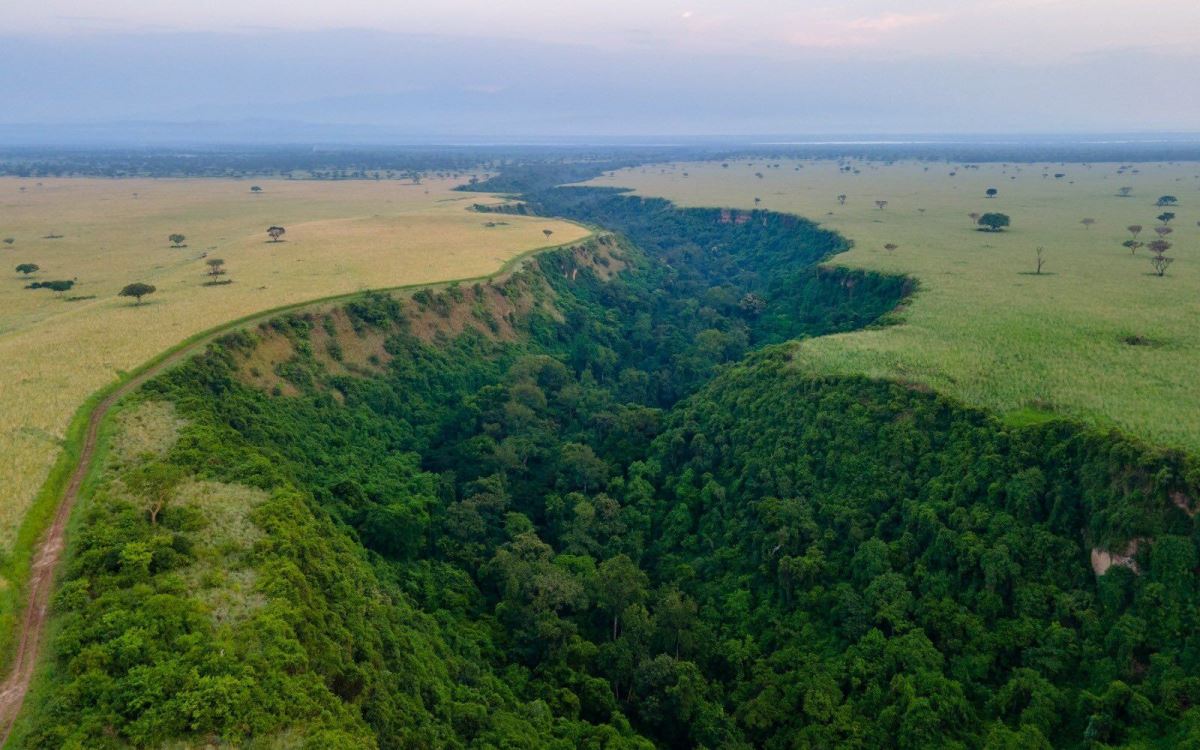
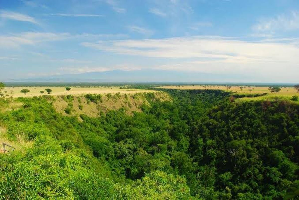
Kyambura Gorge, often called the Valley of Apes, forms a striking natural attraction in southwestern Uganda, carving a 14-kilometer-long rift through the lush terrain between Queen Elizabeth National Park and the Kazinga Channel.
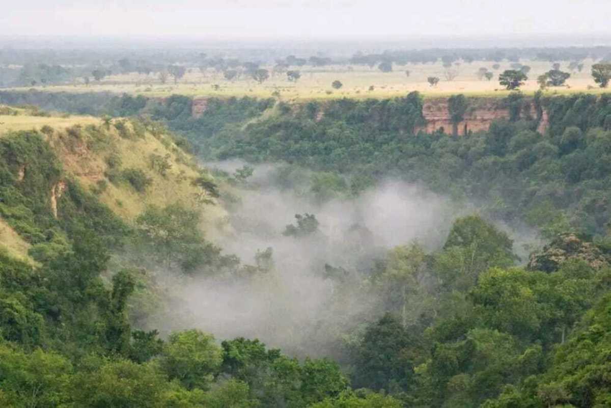
This 100-meter-deep gorge, flanked by steep, forested escarpments, serves as a vital ecological corridor that sustains a diverse array of wildlife and plant species.
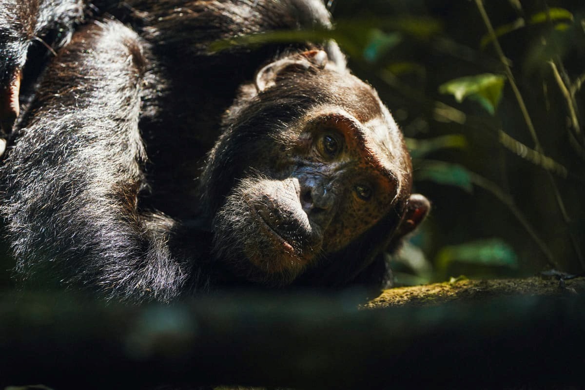
Home to approximately 16 chimpanzee communities, estimated at around 800 individuals, Kyambura Gorge offers a rare window into the lives of these intelligent primates, who navigate its dense undergrowth and vine-draped trees with ease.
Beyond chimpanzees, Kyambura Gorge teems with over 300 bird species, including the vibrant crested crane and Ross's turaco, alongside black-and-white colobus monkeys, red-tailed monkeys, and bushbucks.
The gorge's equatorial rainforest, enriched by underground streams and seasonal mists, supports a rich understory of ferns, orchids, and fruit-bearing trees that form the backbone of this biodiverse habitat.
For visitors, guided treks along Kyambura Gorge trails provide an immersive way to explore this hidden gem, revealing the intricate balance of Uganda's natural heritage.
Location of Kyambura Gorge, Uganda
Kyambura Gorge occupies a prominent position in the southwestern region of Uganda, within the broader Albertine Rift Valley ecosystem.
This 14-kilometer-long and 100-meter-deep gorge extends eastward from the eastern boundary of Queen Elizabeth National Park (Uganda second largest safari park), near the park's Ishasha sector, and stretches toward the Kazinga Channel to the north.
Kyambura Gorge lies primarily in the Kyambura Wildlife Reserve, a protected wildlife area spanning about 156 square kilometers, which encompasses the rift and its surrounding forested escarpments.
Geographically, Kyambura Gorge is situated at coordinates approximately 0°12'S latitude and 30°03'E longitude, placing it in the Rubirizi District of western Uganda, close to the border with the Democratic Republic of the Congo.
Kyambura gorge's placement integrates it into Uganda's interconnected network of conservation zones. To its west, this Uganda attraction borders Queen Elizabeth National Park, a UNESCO Man and the Biosphere Reserve covering over 1,978 square kilometers of savanna, wetlands, and forests.
The Kazinga Channel, a 32-kilometer waterway linking Lakes George and Edward, forms a natural northern extension, facilitating wildlife movement and supporting aquatic habitats.
Further east, the terrain transitions into the rolling hills of the Ankole region, while to the south, Kyambura Gorge approaches the foothills of the Rwenzori Mountains, approximately 50 kilometers away.
This positioning within the Albertine Rift, a tectonic feature running from the Red Sea southward, contributes to the gorge's unique geology, formed by ancient faulting that created the rift and its steep, vine-covered walls.
Access to Kyambura Gorge typically begins from nearby hubs such as Kichwamba or Rubirizi, both reachable via the Mbarara-Kabale highway.
From Entebbe International Airport, the journey covers about 450 kilometers, taking 7-8 hours by road through Masaka and Mbarara.
Local trails descend into the gorge from points along the escarpment, with entry points managed by the Uganda Wildlife Authority.
The surrounding landscape features equatorial rainforest at elevations around 1,200 meters above sea level, influenced by the region's bimodal rainfall pattern, which peaks in March-May and September-November, sustaining the gorge's dense vegetation and wildlife corridors.
This location underscores Kyambura's role as a biodiversity hotspot, linking savanna ecosystems to forested highlands and enabling species like chimpanzees to traverse between habitats.
Kyambura Gorge, Uganda History
Kyambura Gorge, located in southwestern Uganda within the eastern sector of Queen Elizabeth National Park, represents a multifaceted historical narrative that encompasses geological processes, cultural traditions, and modern conservation efforts.
This 11- to 16-kilometer-long gorge, averaging 100 meters in depth and up to 1 kilometer wide, serves as a vital ecological corridor drained by the Kyambura River, which flows into the Kazinga Channel.
Kyambura Gorge’s history unfolds across millennia, from ancient tectonic shifts to colonial-era protections and contemporary ecotourism initiatives.
Kyambura Gorge Geological Origins
The formation of Kyambura Gorge traces back to the dynamic geological activity associated with the East African Rift Valley system, one of the most active rift zones on Earth.
Scientists propose two primary explanations for its creation, both rooted in natural erosive and tectonic forces that have shaped the region's landscape over millions of years.
The more widely accepted theory attributes the gorge's structure to secondary faulting during the broader formation of the Western Rift Valley.
This process began approximately 25 million years ago, when tectonic plates began pulling apart, creating a vast depression interrupted by features like the Rwenzori Mountains.
Compression forces lifted sections of the Earth's crust, while tension generated the main rift floor. Subsequent secondary faulting, smaller fractures within the rift valley, produced subsidiary valleys, including Kyambura Gorge.
These faults allowed the Kyambura River to carve deeper into the weakened bedrock, forming steep escarpments and a narrow, forested trough.
The gorge's position above the east wall of the rift, at altitudes ranging from 700 to 1,100 meters, further supports this model, as it aligns with the area's small hills, crater lakes, and swamps.
An alternative hypothesis emphasizes fluvial erosion by the Kyambura River itself. Proponents suggest that the river, originating from the Kichwamba Escarpment, once flowed with greater volume and velocity, gradually incising the savanna grasslands over thousands of years to create the 100-meter-deep channel.
This view highlights the river's role in transporting sediments and shaping the pointed rocky outcrops and rapids observed today.
Evidence for this includes the river's ongoing flow through the gorge, which sustains underground streams and seasonal mists, contributing to the dense riparian forest. Regardless of the dominant mechanism, the gorge's evolution reflects the interplay of rift tectonics and riverine action, resulting in a landscape of rolling savanna punctuated by this verdant incision.
Cultural and Pre-Colonial Significance
Long before formal protections, Kyambura Gorge held deep cultural importance for the indigenous communities of southwestern Uganda, particularly the Bakiga, Basongora, and Batooro peoples who inhabit the surrounding areas.
The gorge's lush forest and riverine environment made it a practical and spiritual resource, integral to daily life and traditions.
Local oral histories explain the gorge's name, "Kyambura," derived from the Luganda phrase meaning "I couldn't find it."
According to these accounts, heavy rains in the distant past caused the Kyambura River to flood catastrophically, sweeping away villagers, their livestock, and possessions.
When the waters receded, search parties followed the river's path but returned empty-handed, lamenting "Kyambura" in grief.
This event, passed down through generations, underscores the river's power and the gorge's role as a natural force in community memory.
The gorge served as a traditional hunting ground, where locals pursued game such as antelope and forest hogs for sustenance.
The gorge’s diverse flora provided medicinal herbs used to treat ailments, establishing it as a hub for ethnobotanical knowledge.
Spiritually, the dense forest was a site for ancestral communion; communities ventured into the gorge to pray, perform rituals, and connect with forebears, viewing it as a sacred, mysterious realm teeming with life.
These practices highlight the gorge's embedded role in cultural identity, where its biodiversity supported both physical and metaphysical needs.
Surrounding villages and plantations, dating back centuries, relied on the area for water and resources, fostering a sustained human presence without large-scale alteration until colonial times.
Colonial and Post-Independence Conservation History
The modern history of Kyambura Gorge intersects with Uganda's broader conservation timeline, beginning in the colonial era and evolving through independence.
In 1921, the British established the initial protected areas around Lake Edward and Lake George as the Kazinga Dispensary, later expanding into the Queen Elizabeth National Park in 1952 to safeguard wildlife corridors like the one encompassing Kyambura.
The gorge itself fell under the Kyambura Controlled Hunting Area in 1962, a designation that regulated hunting to prevent overhunting of primates and ungulates.
Following Uganda's independence in 1962, the area was upgraded to full game reserve status in 1965, becoming the Kyambura Game Reserve (156 square kilometers), contiguous with Queen Elizabeth National Park.
This buffer zone aimed to protect the gorge's riverine forest, which supports over 300 bird species and serves as a water source for savanna wildlife.
The 1970s and 1980s brought challenges, including political instability and human encroachment; southern portions of the reserve were colonized for agriculture, leading to forest clearance that isolated chimpanzee communities by severing connections to larger forests like Kalinzu and Maramagambo.
Evictions in 1990 restored control, and the land was leased to a private concessionaire, Zwilling, for sustainable management.
The Uganda Wildlife Statute of 1996 renamed it the Kyambura Wildlife Reserve, aligning it with national policies for integrated conservation.
Under the Uganda Wildlife Authority (UWA), established in 1996, efforts intensified to habituate chimpanzees, estimated at 16 communities totaling around 800 individuals, for ecotourism, beginning in the early 2000s.
Permits, costing $50 for international visitors, fund these initiatives, with tracking sessions limited to eight people to minimize disturbance.
Contemporary Developments and Ecotourism
In the 21st century, Kyambura Gorge has emerged as a cornerstone of sustainable tourism within the Queen Elizabeth Protected Area system, which encircles Lake Edward and borders Virunga National Park in the Democratic Republic of Congo.
Volcanoes Safaris, in partnership with UWA, developed the Kyambura Gorge Ecotourism Project, converting a former coffee store into the Kyambura Gorge Lodge overlooking the escarpment.
Opened in the early 2000s, the lodge offers views of the savanna, Rwenzori Mountains, and forest canopy, while generating revenue for community projects like tree planting.
To address chimpanzee isolation, over 6,000 trees have been planted by Uganda Wildlife Authority along former corridors to reconnect populations with the Katsohya-Kitoma forest, enhancing genetic diversity.
New trails, such as the Fig Tree Camp path and reclaimed wetlands, promote guided nature walks and birding, highlighting species like the crested crane and Ross's turaco.
These activities emphasize low-impact exploration. Ongoing challenges include habitat degradation and climate variability, but collaborative efforts continue to balance cultural heritage, biodiversity, and economic benefits, ensuring the gorge's legacy endures for future generations.

